Im Jahr 1915 haben die Kartographen der National Geographic Society damit begonnen die Welt in wunderschönen und verständlichen Karten wiederzugeben.
Bisher wurden 438 Spezialkarten, zehn Atlanten, duzende Globen und etwa 3.000 analoge sowie digitale Karten von der Society veröffentlicht. Viele Menschen finden die spezielle Landkarten-Ästhetik ansprechend und hängen sich die Karten wie Bilder an die Wand.
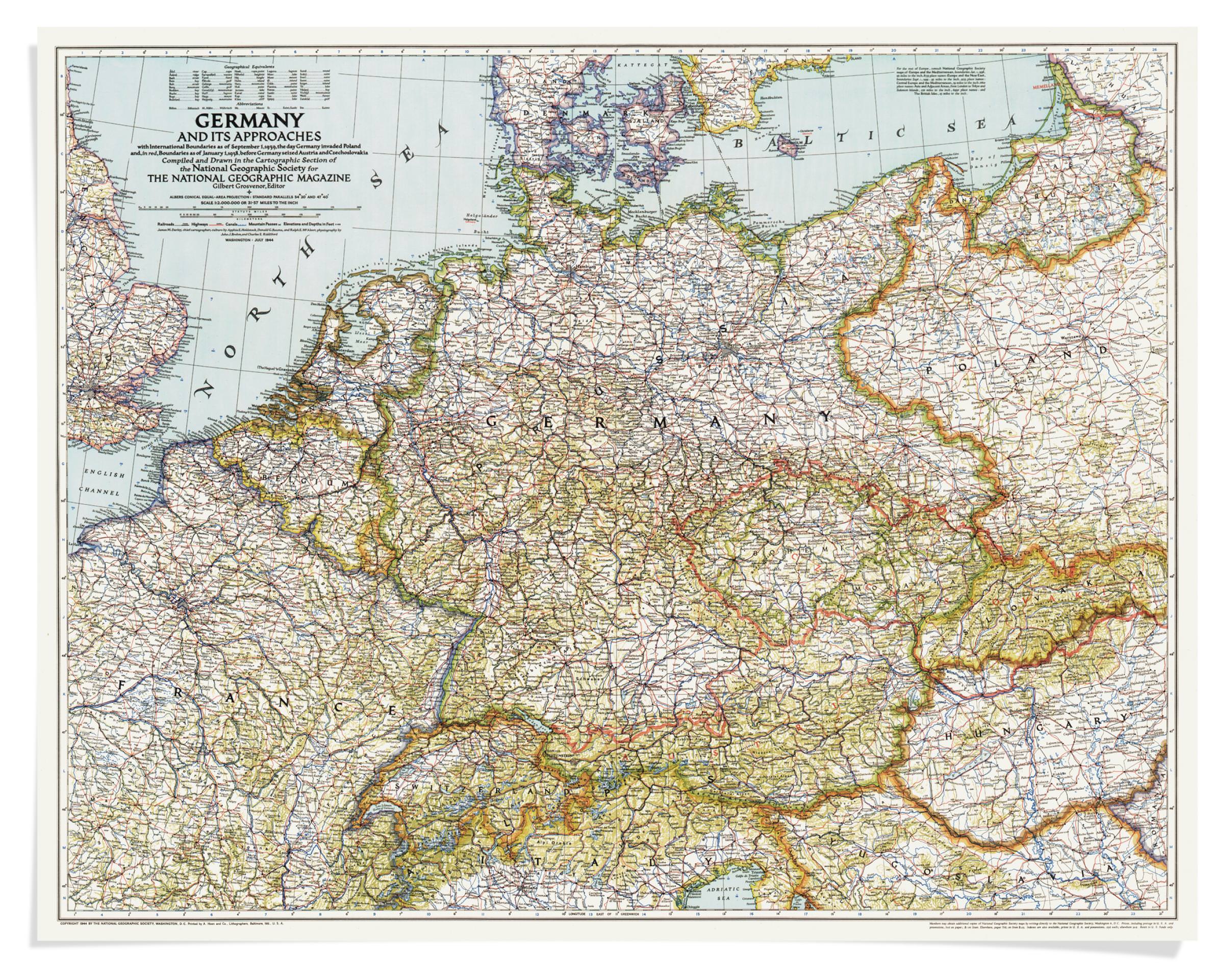
Hinter einigen der National Geographic-Karten steht eine spannende und teils abenteuerliche Entstehungsgeschichte. Manche sind sogar von Gebrauchsgegenständen zu zeitgeschichtlichen Dokumenten geworden, wie etwa die Karte von Deutschland und den angrenzenden Staaten, die General Dwight D. Eisenhower während der Alliierten-Offensive 1945 bei sich trug:
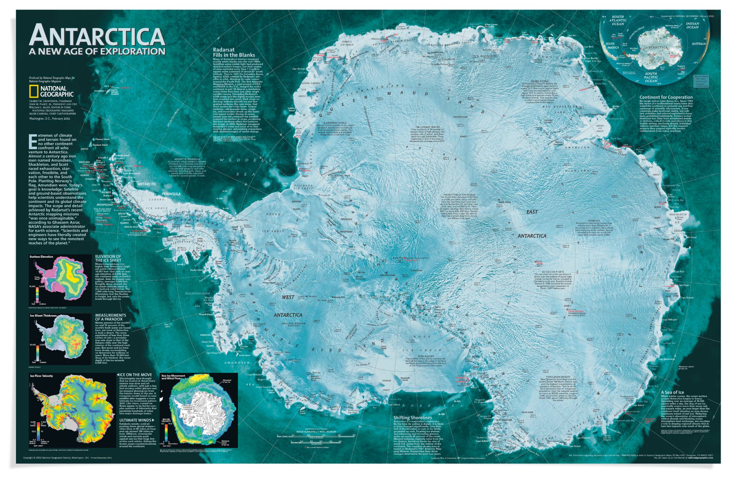
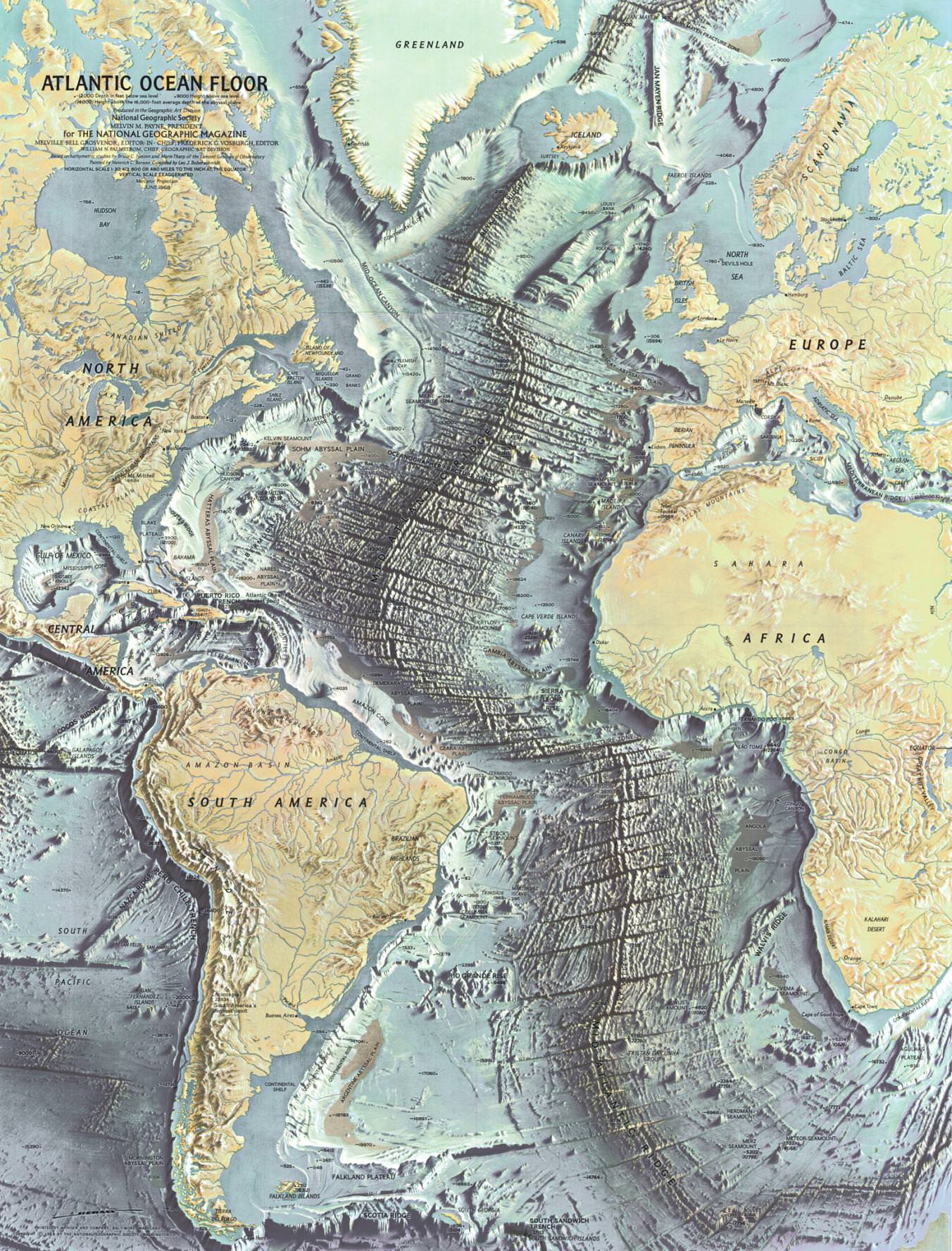
Our maps haven’t just chronicled history; they’ve made it. General Dwight D. Eisenhower carried our map of Germany during his 1945 offensive. When a B-17 carrying Admiral Chester Nimitz got lost in a rainstorm, the pilot landed safely using the Society’s map of the Pacific war theater. The map, Nimitz later wrote Gilbert H. Grosvenor, „lent an unexpected but most welcome helping hand.“ (via NGS Maps)In August 1914, National Geographic magazine published a map of Europe and the Balkan States, subsequently to be the scene of one of the bloodiest conflicts in history—World War I. Editor in Chief Gilbert H. Grosvenor sensed the looming conflict and had the maps printed, stored in the basement, and ready to go. (via NGS Maps)In the early 1900s Roald Amundsen, Ernest Shackleton, and Robert Falcon Scott raced each other to the South Pole. A February 2002 map of the area included surface elevation, ice sheet thickness, and ice flow velocity, as well as the location of the many research bases and automated weather stations. The text notes: „Antarctica is a mapmaker’s nightmare: By the time it is drawn, it is likely to have changed significantly.“ (via NGS Maps)Based on the work of geophysicists Bruce Heezen and Marie Tharp, this 1968 map of the ocean floor helped bring the concept of plate tectonics to a wide audience. Tharp began plotting the depths in 1950 from soundings taken by ships in the Atlantic, but, as a woman, wasn’t allowed on the ships herself. In 1978 she was awarded the Society’s Hubbard Medal for her pioneering research. (via NGS Maps)The November 1988 map of Mount Everest, which took four years to produce, relied on a high-resolution camera carried on the Columbia space shuttle and 160 overlapping aerial images taken from a Learjet flying at 40,000 feet to map 380 square miles of the region. (via NGS Maps)After the worst oil spill in history—the April 2010 explosion and sinking of the Deepwater Horizon rig in the Gulf of Mexico—National Geographic created a map of the many oil rigs off the coasts of Texas, Louisiana, Alabama, and Mississippi. The map’s opposite side shows where the surface oil spread and depicts the rich marine ecosystem that suffered the consequences of the spill. (via NGS Maps)
Für die Bereitstellung unserer triftigen Dienste nutzen wir Cookies und Webseitenstatistik von Google (Detailinformationen). Verstanden!
Privacy & Cookies Policy
Privacy Overview
This website uses cookies to improve your experience while you navigate through the website. Out of these, the cookies that are categorized as necessary are stored on your browser as they are essential for the working of basic functionalities of the website. We also use third-party cookies that help us analyze and understand how you use this website. These cookies will be stored in your browser only with your consent. You also have the option to opt-out of these cookies. But opting out of some of these cookies may affect your browsing experience.
Necessary cookies are absolutely essential for the website to function properly. This category only includes cookies that ensures basic functionalities and security features of the website. These cookies do not store any personal information.
Any cookies that may not be particularly necessary for the website to function and is used specifically to collect user personal data via analytics, ads, other embedded contents are termed as non-necessary cookies. It is mandatory to procure user consent prior to running these cookies on your website.